The unofficial BC Travel & Tourism Guide

Homathko River - Tatlayoko
The history of this area is intimately linked to its geology. Because tectonic forces on the coast of British Columbia split the land into long inlets, travel has always been difficult and much of the BC coast north of Vancouver is, to this day, isolated. Access between the coast and the interior is even more problematic, and although a road was undertaken to connect the coast with the Cariboo goldfields in the mid 19th century by Alfred Waddington, the venture failed, driven back by native hostility and massive snow and rainfall.
But the failure to develop the area allowed for its present day preservation of nature. As part of the Cariboo Chilcotin Land Use Plan, the Homathko River - Tatlayoko Protected Area came to protect one of the few river bottom transitions across the Coast Mountains. The climatic changes are startling, from wet, windward slopes, to interior forests. There are 14 biogeoclimatic zones including Interior Douglas Fir, Montane Spruce, Sub-boreal Pine-Spruce, Englemann Spruce-Subalpine Fir, Alpine Tundra, Coastal Western Hemlock, and Mountain Tundra. The protected area includes significant stands of old growth interior Douglas fir, hemlock and red cedar.
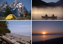
Recreation includes boating at the eastern end of the protected area on frigid, aquamarine-coloured Tatlayoko Lake. The lake is subject to very strong winds, a challenge for small boats, kayaks and canoes, but a blessing for wet-suit clad windsurfers. Downstream of the lake, the most expert of river kayakers can enter the tumultuous white water of the Homathko River. Other activities in the area are dependent on the resolve of the visitor. Because there are no roads or marked trails, only people skilled in orienteering and in backcountry travel can explore deep into the terrain. But properly prepared, visitors can enjoy backcountry travel, wildlife viewing and mountaineering. Seasonal hunting is allowed. For those who enjoy fishing, Mosley Creek, Dumbell Lake and the Homathko River are home to several species of fish including Dolly Varden, Rainbow trout and Bull trout.
Because the area represents a low elevation river ecosystem, transitioning from rainforest to dry interior, wildlife is abundant. The river valley supports moose, grizzly, black bear, mountain goats, mule deer, waterfowl, fish, and numerous other species. It is an important migration route for many animals, and is intimately connected with the life cycle of the Pacific Salmon.
Camping
There is a short road and a forestry recreation site on the eastern shore of the lake. There are no facilities provided. Wilderness camping is allowed.
Location and access
The most reasonable access is from the east side of the Coast Range. Travel west from Williams Lake along Highway 20 for 175 km to just before the tiny community of Tatla Lake. From there follow signs to Tatlayoko Lake, 30 km to the south. The protected area can be accessed by walking along the beach at the north end of Tatlayoko Lake (an area owned by the Nature Conservancy of Canada). Alternatively, it is possible to reach the area by boat from the east shore of Tatlayoko Lake. However, small boats should use caution in crossing this extremely windy lake.
Just click on the following links for more information about nearby communities such as
-
Cariboo Chilcotin Coast
(accommodations in Cariboo Chilcotin Coast) -
Chilanko Forks / Puntzi Lake
(accommodations in Chilanko Forks / Puntzi Lake) -
Chilko Lake
(accommodations in Chilko Lake) -
Nemaiah Valley
(accommodations in Nemaiah Valley) -
Tatla Lake
(accommodations in Tatla Lake) -
Tatlayoko Lake
(accommodations in Tatlayoko Lake)