The unofficial BC Travel & Tourism Guide
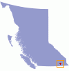
Just south of Kootenay Lake in southeastern British Columbia, the City of Creston sits in an agricultural valley of rolling hills, fields and orchards. It is set amongst some of the most scenic mountain terrain in BC, with the Purcells to the east and Selkirks to the west. Only 5% of the total landmass of BC is suitable for agriculture, making the Creston area quite rare in a province. With relatively mild winters and a long growing season, it is second only to the Okanagan Valley for fruit production, and also produces vegetables and grain. Just west of town, the Kootenay River flows north into Kootenay Lake.
Creston has a population of about 5000 and hosts the Blossom Festival in May and the Music Festival and Fall Fair in September. The city has a museum featuring artifacts from its pioneering and gold panning days; murals depicting historical events and present-day life; the Columbia Brewery, home of iconic Kokanee beer; a wetlands wildlife sanctuary; and the native museum, Yaqan Nuki Heritage Centre, south of the city.
Activities in the area include excellent hiking in both mountain ranges; whitewater rafting and kayaking; fishing in one of dozens of smaller lakes as well as Kootenay Lake itself; mountain biking; snowshoeing, cross country, backcountry and cat-skiing; as well as golf at two scenic courses, Creston Golf Club, and Canyon Heights. A drive up the shores of Kootenay Lake offers great views of the surrounding peaks as well as beaches. Nearby Stagleap Provincial Park is situated on the highest all-weather pass in Canada, and is renowned for offering excellent access to the backcountry in summer and winter.
History:
Originally, the Archplat, or Flatbow Indians, first lived in the lower area of the Kootneys now apart of where Creston stands on the Kootney Lake. The origin of the Kootenay name stems from "coo," meaning water, and "tinneh," meaning people. On the edge of the Kootenay River in 1808, near the area known now as Creston, John Rykert first settled as an acting Canadian Customs and Immigration Officer. He built a one room building that still stands today just north of the United States Boarder.
Creston received its name in 1899 from Fred Little, one of three men who arrived in the area to claim part of the land for development. He had named it after the town of Creston he had lived in, in the United States.
Creston’s lumber mills and lumber production made significant contributions during the early construction of the Canadian Pacific Railways extension (Crows Nest Pass) in 1898. Production of wood materials and the introduction of boarder trade in the earlier 1900’s was the community’s initial resource. Creston also saw the passing of the trains and mining of ore from Alice Siding and other areas, which became lucrative for the small town. Around the same time as lumber the lumber industry in Creston began booming, the first orchards struck massive fruit production.
Location and access:
Creston is on the Okanagan and BC Rockies Circle Tour. It is situated at the junction of Highway 3, 3A and Highway 21, just 11 kilometers north of the US border.
For more information please visit www.crestonbc.com/chamber
Creston Accommodations
Creston Things to Do
British Columbia

