The unofficial BC Travel & Tourism Guide

Carmanah Walbran
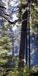
Photo: Daniela Herold
Amongst such dense abundance, there is space, and it spreads out before your eyes like an enormous green cathedral. The ground is spongy from thousands of years of organic decay, and in this preserved pocket of wilderness, you are reminded of what most of Vancouver Island once was. In here, untouched by man, there are a thousand denizens of the forest observing you. You are a visitor to an ancient place, 10,000 years in the making. Before you lies over ten kilometres of trails that follow Carmanah Creek up and downstream.
Carmanah Walbran Provincial Park is without a doubt one of the most remarkable wild places on Vancouver Island. The lower Carmanah Valley was declared a provincial park in 1990. The addition of the Walbran and upper Carmanah Valleys in 1995, completes the protection of the Carmanah Creek watershed and the southern portion of the Walbran Creek watershed.
The luxuriously forested sanctuary offers protection to diverse forest ecosystems, including a large Sitka spruce ecosystem that represents 2% of BC's remaining old-growth forest. The Park is home to some of the world's largest spruce trees, some reaching heights in excess of 95 meters and living for 800 years or more, and also to gnarled cedars estimated to be well over 1,000 years old. The park provides unique opportunities for forest research and education in the areas of biodiversity, wildlife and fisheries habitat. This dynamic system has developed over thousands of years and functions perfectly if left undisturbed.
Hiking
Hiking trails in the Carmanah Valley provide access to many of the park’s notable natural features, including some of the area’s largest trees. Many trails are extremely muddy, primitive and difficult. Be equipped with rain gear and good hiking boots. There is no access to the West Coast Trail.
Camping
Wilderness camping is allowed at several locations upstream from "The Three Sisters" in the Carmanah Valley, with walk-in camping available above the Valley where the Carmanah Valley Trailhead is located. This is the only area in the park where campfires are permitted. Campsites with tent pads, picnic tables and fire rings are provided beyond the parking area on the service road. Short-term vehicle camping is permitted in the parking lot.
The primary destination point of visitors to the park is the Park Facility Operator’s station, located at the lower Carmanah Valley Trailhead. This area offers parking, pit toilets and walk-in camping above the valley.
Location:
Carmanah Walbran Provincial Park is located 20 km northwest of Port Renfrew on the southwestern coast of Vancouver Island. There are three different routes leading to the Caycuse River Bridge, which is the only way to access the park.
Access routes:
From Port Alberni: Follow the Bamfield Road for approximately 40 km to the Franklin River Junction. At the junction, turn left onto South Main and proceed eastward, past the logging camp buildings and toward Nitinat Lake. Continue on South Main for approximately 23 km to the Nitinat River Bridge. Stay on South Main until reaching the Caycuse River Bridge.
From Port Renfrew: Follow the Lake Cowichan Connector Road north to Honeymoon Bay. At Honeymoon Bay, turn left and proceed along South Shore Road, which becomes Nitinat Main, continuing to the junction of Nitinat Main and South Main. Turn left onto South Main and proceed to the Caycuse River Bridge.
From Lake Cowichan: Follow South Shore Road past Gordon Bay Provincial Park to the Nitinat Main, or follow the North Shore Road through Youbou to the Nitinat Main. Continue along Nitinat Main till it connects with Junction South. Turn left onto South Main and proceed to the Caycuse River Bridge.
Once you have crossed the Caycuse River Bridge, turn right immediately and proceed on Rosander Main for approximately 29 km to the park.
Safety:
Access to the remote and rugged park is via private logging roads only. These roads are at times narrow, bumpy, and used frequently by industrial logging trucks. Always drive with your headlights on as visibility may be limited due to dust and adverse weather. Logging trucks have the right of way at all times.
Park visitors should carry a first aid kit at all times. In the case of an emergency, you should contact either Enquiry BC at (250) 387-6121, the RCMP in Port Alberni or Lake Cowichan, or dial 911. The closest emergency telephone is located at the Didtidaht Reserve. The closest hospitals are located in Port Alberni and Duncan.
Just click on the following links for more information about nearby communities such as